
Description
Garmin GPSMAP 943 Chartplotter with BlueChart® g3 coastal charts and LakeVü g3
Model: 010-02366-01- Easily integrate with more engines.
- Connect to compatible third-party devices with OneHelm™ digital switching.
- Easily build your marine system using the best of network connectivity.
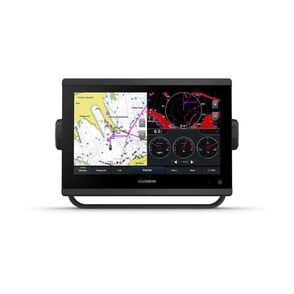
- Navigate any waters with preloaded mapping and coastal charts.
- Take the guesswork out of sailing with clear laylines and more - right on the screen.
- Manage your marine experience from nearly anywhere1.
With 60% more display pixels and nearly double the processing power of previous-generation 9" GPSMAP devices, this crisp high-resolution chartplotter integrates seamlessly into your Garmin marine system.
With its added processing power and new slimline design featuring edge-to-edge glass and a smaller unit footprint, it’s easy to retrofit this 9" plotter in a wider range of dash configurations.
New higher-resolution 9" displays offer improved sunlight readability with 60% more pixels than previous-generation 9" GPSMAP devices.
Experience unparalleled coverage and detail with preloaded BlueChart® g3 coastal charts and LakeVü g3 inland maps featuring integrated Garmin and Navionics® content and Auto Guidance technology.
Upgrade to our reliable premium charts3, which add even more unparalleled features, such as high-resolution relief shading, to help you on each trip.
View laylines, race start line guidance, enhanced wind rose, heading and course-over-ground lines, true wind data fields and tide/current/time slider, wind angle, set and drift, wind speed and more.
Specifications| General | |
| PHYSICAL DIMENSIONS | 9.2"" x 6.4"" x 3"" (23.3 x 16.2 x 7.6 cm) |
| DISPLAY SIZE | 7.8"" x 4.4""; 9.0"" diagonal |
| DISPLAY RESOLUTION | 1280 x 720 pixels |
| DISPLAY TYPE | WXGA display |
| WEIGHT | 3.6 lbs (1.6 kg) |
| WATER RATING | IPX7 |
| POLARIZED SUPPORT | Yes |
| POWER CONSUMPTION | Max power usage at 10 Vdc: 22 W Typical current draw at 12 Vdc: 1.3 A Max current draw at 12 Vdc: 1.8 A |
| ANTENNA | Internal or external over NMEA 2000 |
| MOUNTING OPTIONS | Bail, flush or flat |
| RECEIVER | 10 Hz high-sensitivity |
| GARMIN MARINE NETWORK™ PORTS | 1 |
| Maps & Memory | |
| PRELOADED MAPS | BlueChart® g3 (coastal maps) and LakeVü g3 (inland maps) |
| ACCEPTS DATA CARDS | 2 microSD™ cards (back of unit) |
| WAYPOINTS | 5,000 |
| TRACK LOG | 50,000 points; 50 saved tracks |
| ROUTES | 100 |
| Outdoor Recreation | |
| TIDE TABLES | Yes |
| Chartplotter Features | |
| GARMIN RADAR COMPATIBLE | Yes |
| GARMIN SONAR COMPATIBLE | Yes (with external black box, sold separately) |
| GARMIN SMARTMODE COMPATIBLE (CUSTOMIZABLE MONITOR PRESETS) | Yes |
| SUPPORTS AIS (TRACKS TARGET SHIPS POSITION) | Yes |
| SUPPORTS DSC (DISPLAYS POSITION DATA FROM DSC-CAPABLE VHF RADIO) | Yes |
| SUPPORTS FUSION-LINK™ COMPATIBLE RADIOS | Yes |
| GSD™ BLACK BOX SONAR SUPPORT | Yes |
| GCV™ BLACK BOX SONAR SUPPORT | Yes |
| ACTIVECAPTAIN COMPATIBLE | Yes |
| GRID™ (GARMIN REMOTE INPUT DEVICE) COMPATIBLE | Yes |
| WIRELESS REMOTE COMPATIBLE | Yes |
| SAILING FEATURES | Yes |
| Sonar Features & Specifications | |
| CHIRP SONAR TECHNOLOGY | Yes (with external black box, sold separately) |
| CLEARVü | Yes (with external black box, sold separately) |
| SIDEVü | Yes (with external black box, sold separately) |
| Connections | |
| NMEA 2000® COMPATIBLE | Yes |
| NMEA 0183 INPUT PORTS | 1 (Differential) |
| NMEA 0183 OUTPUT PORTS | 1 (Differential) |
| VIDEO INPUT PORTS | 1 BNC |
| WIRELESS CONNECTIVITY | Yes |
| J1939 COMPATIBLE | Yes |
What's in the Box:
- GPSMAP 943 chartplotter
- microSD™ card preinstalled
- Power cable
- NMEA 2000® T-connector
- NMEA 2000 drop cable (2 meters)
- Bail mount kit with knobs
- Flush mount kit with gasket
- Protective cover
- Trim piece snap covers
- Documentation